Travle USA: How the US States Map Works, With Tips
Travle USA is the US states version of Travle, played at travle.earth/usa. The basic task is familiar: connect the endpoints using as few states as possible along a continuous route between a start and an end state. Plan the chain before guessing. Single-neighbour states like Maine force your first step, and every land route out of New England passes through New York.
Part of our complete Travle guide, with rules, worked examples and tips.
Play the official US states map ↗Official site. dlewiki is an unofficial guide.
Indiana to Montana: why Michigan costs two guesses
The shorter intermediate chain is Illinois → Iowa → South Dakota. GeoWizard’s recorded attempt used five guesses; the result revealed this three-guess alternative.
Historical video example, not today’s answer. Cropped gameplay frames are credited below. Tap an image to enlarge it or use its timestamp to watch the original moment.
The mistake: Michigan does not touch Minnesota
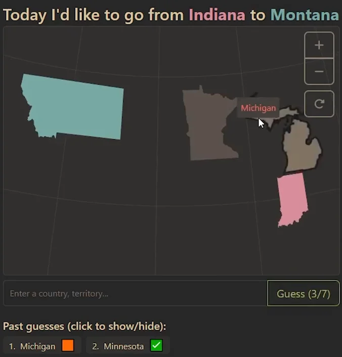
Michigan is linked to Indiana, but Minnesota stays gray. The Upper Peninsula touches Wisconsin, not Minnesota. The green check beside Minnesota does not mean it already joins your route: map connectivity and guess quality are separate.
The result: compare against the three-state alternative

The visible result excerpt shows 5 guesses versus a minimum of 3. To avoid the northern detour on this historical puzzle, plan Indiana → Illinois → Iowa → South Dakota → Montana before entering guesses. Iowa's short border with South Dakota is the useful link.
How Travle USA works
The US map asks for states in place of countries. Build a continuous chain between the supplied endpoints within the displayed allowance. Check the current USA Help for hints, scoring and local border conventions; the recorded example below is evidence for that particular route, not a test of every current setting.
Worked example: Maine to Ohio
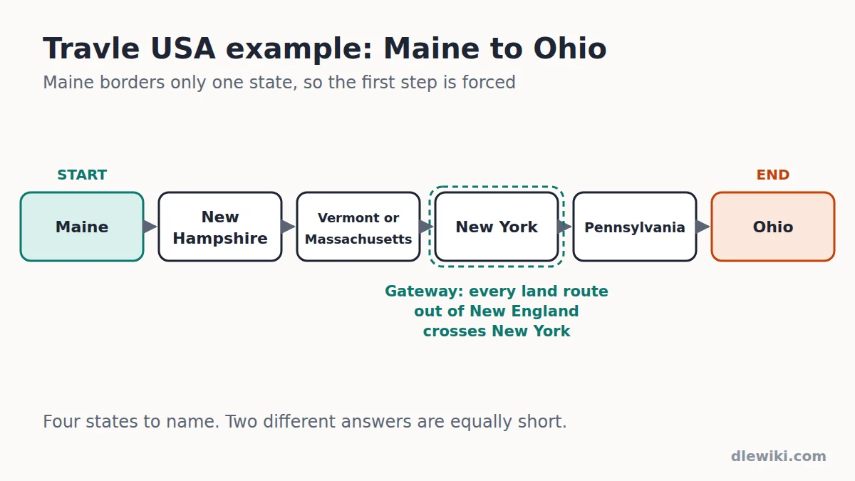
This is a geography-based planning illustration, not a recorded DLEWiki play-test. Maine has exactly one neighbouring US state, New Hampshire, so the first step is forced. From New Hampshire you can go through Vermont or Massachusetts. Both reach New York, which borders Pennsylvania, which borders Ohio. That gives four intermediate states to try in the official game; check its current map and any exclusions.
Worked example: Rhode Island to Wisconsin
Rhode Island borders Connecticut, which leads to New York, Pennsylvania and Ohio. From Ohio, Michigan reaches Wisconsin through the Upper Peninsula, which beats going through Indiana and Illinois by one state. In the same video Indiana still showed green, which confused the player. A green guess is not proof you are on the single best route, so count the alternatives yourself.
Forced steps: states with few neighbours
Start your plan with the states that leave you no choice:
| State | Neighbouring states | What it means for a route |
|---|---|---|
| Maine | New Hampshire only | Every route to or from Maine passes New Hampshire |
| Florida | Georgia, Alabama | Routes out of Florida begin with one of these two |
| Washington | Oregon, Idaho | The Pacific Northwest funnels through these two |
| Delaware | Maryland, Pennsylvania, New Jersey | Only three exits; check which one heads toward your end state |
The New York gateway
New England (Maine, New Hampshire, Vermont, Massachusetts, Rhode Island and Connecticut) touches the rest of the country only through New York. Any route that leaves New England by land crosses New York, so put it in your plan straight away.
Central hubs
Tennessee and Missouri each border eight states, more than any other state. Routes across the middle of the country often pass through one of them. When you plan a coast-to-coast route, try both and count which gives fewer states.
Watch-outs for the US map
- Alaska and Hawaii share no land border with another state. Check the in-game map for how they are handled before you plan a route through either.
- Four Corners: Utah, Colorado, Arizona and New Mexico meet at a single point. Whether diagonal neighbours like Arizona and Colorado count as touching is a map rule, so test it in practice mode.
- Michigan has two peninsulas joined by the Mackinac Bridge. The recorded game uses Michigan to reach Wisconsin through the Upper Peninsula. This does not establish unrestricted water hops within every state. Michigan does not border Minnesota by land.
More Travle maps
Travle also has more than 80 other maps, including county maps for 49 US states (California is at travle.earth/usaca). See every Travle map. County maps are harder than they look. In GeoWizard's Cardiff to Essex game on the Great Britain map, a rushed guess through the Welsh valleys cost the Perfect. The narrow contact between Berkshire and Greater London still counted as a border. Use the UK naming walkthrough to see how county answers differ from World-country answers. Each map adds its own quirks, so read its in-game Help before your first route.
Video guides
This country borders game is highly addictive [Travle Country Routes] by GeoWizard on YouTube
Frequently asked questions
Where can I play Travle USA?
At travle.earth/usa, the official US states map. Enter state names and check that map's Help for current hints and scoring.
Which US state borders only one other state?
Maine. Its only neighbouring state is New Hampshire, so any Travle USA route from or to Maine passes through New Hampshire.
Which states border the most other states in Travle USA?
Tennessee and Missouri each border eight states. They make strong central hubs when you plan a route across the middle of the country.
Does Michigan connect to Wisconsin in Travle USA?
Yes. Michigan's Upper Peninsula borders Wisconsin, so Michigan can be a shortcut west from Ohio. It does not border Minnesota by land, though.
Are Alaska and Hawaii in Travle USA?
Neither shares a land border with another state. Check the game's map for how it handles them before planning a route through either.